|
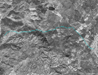
This route is very interesting for people with ornithological and historical interest. Walking along plains and fields we may reach the shore of the river Erjas. This river is a frontier in la Raya region, where the Peñafiel´s rocky Castle is. This castle was called Racha-Rachel by the Arabs and close to it, the very old Peñafiel village was established. This village was deserted later on.
In the fluvial embankments there is a colony of tawny vultures, and other rupícolas birds, threatened like the black stork, the royal owl, the eagle perdicera or the alimoche.
Our route starts at the Major Plaza. There we can visit San Andrés church -very interesting- , the Palace of the Encomienda and the Royal Factory of the Silk. After that, we will go through from Rollo Square to Calleja Larga. Then, we will turn aside for a way, rather alley, which will take us up to the front door of the Castle. Before that we will pass in front of the fountain of the Escoba, possibly contemporary to Peñafiel´s village, which has now turned into clear ruins. As a prove of that, numerous milestones of stone have appear in the surrounding areas of the fortress.
In the base of the castle there is one of the best viewing-points of Erjas, the best point for the rapaces´ observation. For sure we will be impressed by the flight of the tawny vultures gliding below our heads or at a the sight height.
|